
Make a donation
Gear up for your next adventure:
As an Amazon Associate, this site earns from qualifying purchases at no extra cost to you.
Lepe topographic map
Click on the map to display elevation.
Make a donation
Gear up for your next adventure:
As an Amazon Associate, this site earns from qualifying purchases at no extra cost to you.
About this map
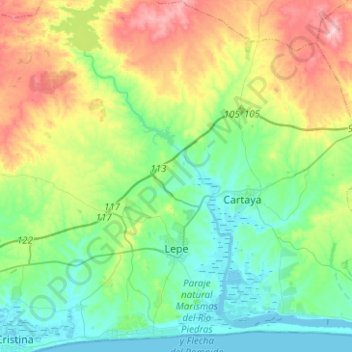
Name: Lepe topographic map, elevation, terrain.
Location: Lepe, Costa Occidental, Huelva, Andalusia, Spain (37.20389 -7.30851 37.38785 -7.05829)
Average elevation: 56 m
Minimum elevation: -3 m
Maximum elevation: 181 m
Make a donation
Gear up for your next adventure:
As an Amazon Associate, this site earns from qualifying purchases at no extra cost to you.
Other topographic maps
Click on a map to view its topography, its elevation and its terrain.
La Antilla
Spain > Andalusia > Costa Occidental > Lepe
La Antilla is located along the southern coast of Spain, near the border with Portugal. Its average elevation is 12 meters above the sea level.
Average elevation: 12 m
Make a donation
Gear up for your next adventure:
As an Amazon Associate, this site earns from qualifying purchases at no extra cost to you.