
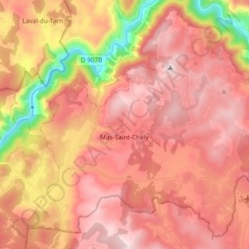
Mas-Saint-Chély topographic map
Interactive map
Click on the map to display elevation.
About this map
Name: Mas-Saint-Chély topographic map, elevation, terrain.
Average elevation: 893 m
Minimum elevation: 447 m
Maximum elevation: 1,149 m
Other topographic maps
Click on a map to view its topography, its elevation and its terrain.
Chaudeyraguet
France > Occitanie > Lozère > Chaudeyrac
Chaudeyraguet, Chaudeyrac, Mende, Lozère, Occitanie, France métropolitaine, 48170, France
Average elevation: 1,231 m
Castanet
France > Occitanie > Lozère > Pourcharesses
Castanet, Pourcharesses, Mende, Lozère, Occitanie, France métropolitaine, 48800, France
Average elevation: 813 m
Bel-Air-Val-d'Ance
Bel-Air-Val-d'Ance, Mende, Lozère, Occitanie, France métropolitaine, 48600, France
Average elevation: 1,111 m
Parpaillon
France > Occitanie > Lozère > Auroux
Parpaillon, Auroux, Mende, Lozère, Occitanie, France métropolitaine, 48600, France
Average elevation: 1,155 m
Mas-d'Orcières
France > Occitanie > Lozère > Mont Lozère et Goulet
Mas-d'Orcières, Mont Lozère et Goulet, Mende, Lozère, Occitanie, France métropolitaine, 48190, France
Average elevation: 1,331 m
Lachamp-Ribennes
Lachamp-Ribennes, Mende, Lozère, Occitanie, France métropolitaine, France
Average elevation: 1,067 m
Le Masbonnet
France > Occitanie > Lozère > Le Pompidou
Le Masbonnet, Le Pompidou, Florac, Lozère, Occitanie, France métropolitaine, 48110, France
Average elevation: 777 m
Fraissinet-de-Lozère
France > Occitanie > Lozère > Pont de Montvert - Sud Mont Lozère
Fraissinet-de-Lozère, Pont de Montvert - Sud Mont Lozère, Florac, Lozère, Occitanie, France métropolitaine, 48220, France
Average elevation: 1,222 m
Le Recoux
France > Occitanie > Lozère > Massegros Causses Gorges
Le Recoux, Massegros Causses Gorges, Florac, Lozère, Occitanie, France métropolitaine, 48500, France
Average elevation: 886 m
Cheylard-l'Évêque
Cheylard-l'Évêque, Mende, Lozère, Occitanie, France métropolitaine, 48300, France
Average elevation: 1,224 m
Brame-Loup
France > Occitanie > Lozère > Grandvals
Brame-Loup, Grandvals, Mende, Lozère, Occitanie, France métropolitaine, 48260, France
Average elevation: 1,188 m
Chassignoles
France > Occitanie > Lozère > Rimeize
Chassignoles, Rimeize, Mende, Lozère, Occitanie, France métropolitaine, 48200, France
Average elevation: 1,008 m
Serverette
Serverette, Mende, Lozère, Occitanie, France métropolitaine, 48700, France
Average elevation: 1,030 m
Chaudeyrac
Chaudeyrac, Mende, Lozère, Occitanie, France métropolitaine, 48170, France
Average elevation: 1,239 m
Les Fours
France > Occitanie > Lozère > La Fage-Montivernoux
Les Fours, La Fage-Montivernoux, Mende, Lozère, Occitanie, France métropolitaine, 48310, France
Average elevation: 1,187 m
Les Salses
France > Occitanie > Lozère > Recoules-d'Aubrac
Les Salses, Recoules-d'Aubrac, Mende, Lozère, Occitanie, France métropolitaine, 48260, France
Average elevation: 1,168 m
Saint-Paul-le-Froid
Saint-Paul-le-Froid, Mende, Lozère, Occitanie, France métropolitaine, 48600, France
Average elevation: 1,249 m
Parc national des Cévennes (cœur)
France > Occitanie > Lozère > Vebron
Parc national des Cévennes (cœur), Vebron, Florac, Lozère, Occitanie, France métropolitaine, 48400, France
Average elevation: 757 m
48500
France > Occitanie > Lozère > La Canourgue
48500, La Canourgue, Mende, Lozère, Occitanie, France métropolitaine, France
Average elevation: 840 m
Banassac
France > Occitanie > Lozère > Banassac-Canilhac
Banassac, Banassac-Canilhac, Mende, Lozère, Occitanie, France métropolitaine, 48500, France
Average elevation: 706 m
Cocurès
France > Occitanie > Lozère > Bédouès-Cocurès
Cocurès, Bédouès-Cocurès, Florac, Lozère, Occitanie, France métropolitaine, 48400, France
Average elevation: 732 m
La Rouzeire
France > Occitanie > Lozère > Lajo
La Rouzeire, Lajo, Mende, Lozère, Occitanie, France métropolitaine, 48120, France
Average elevation: 1,256 m
Recoules-d'Aubrac
Recoules-d'Aubrac, Mende, Lozère, Occitanie, France métropolitaine, 48260, France
Average elevation: 1,178 m
Saint-Laurent-de-Muret
Saint-Laurent-de-Muret, Mende, Lozère, Occitanie, France métropolitaine, 48100, France
Average elevation: 1,144 m
Marchastel
Marchastel, Mende, Lozère, Occitanie, France métropolitaine, 48260, France
Average elevation: 1,228 m
La Panouse
La Panouse, Mende, Lozère, Occitanie, France métropolitaine, 48600, France
Average elevation: 1,315 m
Pierrefiche
Pierrefiche, Mende, Lozère, Occitanie, France métropolitaine, 48300, France
Average elevation: 1,173 m
Moissac-Vallée-Française
Moissac-Vallée-Française, Florac, Lozère, Occitanie, France métropolitaine, 48110, France
Average elevation: 480 m
Le Villeret
France > Occitanie > Lozère > Saint-Jean-la-Fouillouse
Le Villeret, Saint-Jean-la-Fouillouse, Mende, Lozère, Occitanie, France métropolitaine, 48170, France
Average elevation: 1,219 m
Les Gouttes
France > Occitanie > Lozère > Peyre en Aubrac
Les Gouttes, Fau-de-Peyre, Peyre en Aubrac, Mende, Lozère, Occitanie, France métropolitaine, 48130, France
Average elevation: 1,168 m
Boirelac
France > Occitanie > Lozère > Saint-Paul-le-Froid
Boirelac, Saint-Paul-le-Froid, Mende, Lozère, Occitanie, France métropolitaine, 48600, France
Average elevation: 1,201 m
Prévenchères
Prévenchères, Mende, Lozère, Occitanie, France métropolitaine, 48800, France
Average elevation: 916 m
Saint-Étienne-du-Valdonnez
Saint-Étienne-du-Valdonnez, Mende, Lozère, Occitanie, France métropolitaine, 48000, France
Average elevation: 1,057 m
Le Collet-de-Dèze
Le Collet-de-Dèze, Florac, Lozère, Occitanie, France métropolitaine, 48160, France
Average elevation: 519 m
L'Herm
France > Occitanie > Lozère > Saint-Flour-de-Mercoire
L'Herm, Saint-Flour-de-Mercoire, Mende, Lozère, Occitanie, France métropolitaine, 48300, France
Average elevation: 1,085 m
Les Salces
France > Occitanie > Lozère > Pelouse
Les Salces, Pelouse, Mende, Lozère, Occitanie, France métropolitaine, 48000, France
Average elevation: 1,034 m