
Make a donation
Gear up for your next adventure:
As an Amazon Associate, this site earns from qualifying purchases at no extra cost to you.
Alpe Devero topographic map
Click on the map to display elevation.
Make a donation
Gear up for your next adventure:
As an Amazon Associate, this site earns from qualifying purchases at no extra cost to you.
Alpe Devero
L'Alpe Devero è una località alpina che si trova al centro della Valle Devero. Il piccolo centro abitato è una frazione di Baceno, un comune della provincia del Verbano-Cusio-Ossola. L'Alpe, storico insediamento di pascoli per l'allevamento del bestiame, si trova a 1634 metri s.l.m. di altitudine e si trova all'interno dell'area protetta del Parco naturale dell'Alpe Veglia e dell'Alpe Devero.
Make a donation
Gear up for your next adventure:
As an Amazon Associate, this site earns from qualifying purchases at no extra cost to you.
About this map
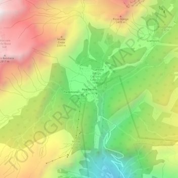
Name: Alpe Devero topographic map, elevation, terrain.
Average elevation: 1,949 m
Minimum elevation: 1,107 m
Maximum elevation: 2,897 m
Make a donation
Gear up for your next adventure:
As an Amazon Associate, this site earns from qualifying purchases at no extra cost to you.