
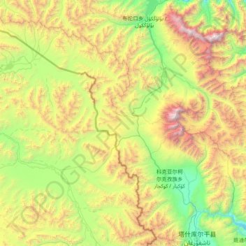
塔合曼乡 تاغارما يېزىسى topographic map
Interactive map
Click on the map to display elevation.
About this map
Name: 塔合曼乡 تاغارما يېزىسى topographic map, elevation, terrain.
Average elevation: 4,282 m
Minimum elevation: 2,905 m
Maximum elevation: 7,593 m
Other topographic maps
Click on a map to view its topography, its elevation and its terrain.
Gasherbrum II
China > Xinjiang > Taxkorgan Tajik Autonomous County > Dafdar
Gasherbrum II is located on the border of Gilgit–Baltistan, Pakistan, and Xinjiang, China. It is part of the Karakoram mountain range in the Himalayas, and located at the top of the Baltoro Glacier. With an elevation of 8,034 metres (26,358 ft) it is the third-highest member of the Gasherbrum group, behind…
Average elevation: 7,098 m
Qoghushluq
China > Xinjiang > Taxkorgan Tajik Autonomous County > 库科西鲁格乡 قوغۇشلۇق يېزىسى
Average elevation: 2,984 m