Geolocate

Taiga topographic map

Interactive map

Click on the map to display elevation.

About this map

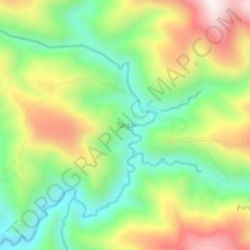
Name: Taiga topographic map, elevation, terrain.

Location: Taiga, Pegunungan Arfak, West Papua, Western New Guinea, Indonesia (-1.39312 133.73750 -1.35312 133.77750)

Average elevation: 1,646 m

Minimum elevation: 1,308 m

Maximum elevation: 2,124 m

Other topographic maps

Click on a map to view its topography, its elevation and its terrain.

Danau Anggi Gida

Indonesia > West Papua > Pegunungan Arfak > Krobut / Kiwot

Danau Anggi Gida, Krobut / Kiwot, Pegunungan Arfak, West Papua, Western New Guinea, Indonesia

Average elevation: 1,957 m

Membey

Indonesia > West Papua > Pegunungan Arfak

Membey, Pegunungan Arfak, West Papua, Western New Guinea, Indonesia

Average elevation: 2,271 m

Minyeimemut

Indonesia > West Papua > Pegunungan Arfak

Minyeimemut, Pegunungan Arfak, West Papua, Western New Guinea, Indonesia

Average elevation: 2,175 m