
Péninsule acadienne topographic map
Interactive map
Click on the map to display elevation.
About this map
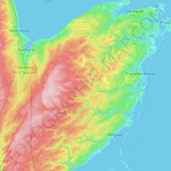
Name: Péninsule acadienne topographic map, elevation, terrain.
Average elevation: 48 m
Minimum elevation: -3 m
Maximum elevation: 179 m
Other topographic maps
Click on a map to view its topography, its elevation and its terrain.
Allardville
Canada > Nouveau-Brunswick > Allardville Parish
Allardville, Allardville Parish, Comté de Gloucester, Nouveau-Brunswick, E8L 1K2, Canada
Average elevation: 160 m