
Laupen topographic map
Interactive map
Click on the map to display elevation.
About this map
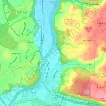
Name: Laupen topographic map, elevation, terrain.
Average elevation: 531 m
Minimum elevation: 475 m
Maximum elevation: 615 m
Other topographic maps
Click on a map to view its topography, its elevation and its terrain.
Bern
Schweiz > Bern > Verwaltungskreis Bern-Mittelland
Bern, Verwaltungskreis Bern-Mittelland, Verwaltungsregion Bern-Mittelland, Bern, Schweiz
Average elevation: 612 m
Neuenegg
Schweiz > Bern > Verwaltungskreis Bern-Mittelland
Neuenegg, Verwaltungskreis Bern-Mittelland, Verwaltungsregion Bern-Mittelland, Bern, 3176, Schweiz
Average elevation: 608 m
Gysenstein
Schweiz > Bern > Verwaltungskreis Bern-Mittelland
Gysenstein, Konolfingen, Verwaltungskreis Bern-Mittelland, Verwaltungsregion Bern-Mittelland, Bern, 3503, Schweiz
Average elevation: 694 m
Muri bei Bern
Schweiz > Bern > Verwaltungskreis Bern-Mittelland
Muri bei Bern, Verwaltungskreis Bern-Mittelland, Verwaltungsregion Bern-Mittelland, Bern, Schweiz
Average elevation: 568 m
Rümligen
Schweiz > Bern > Verwaltungskreis Bern-Mittelland
Rümligen, Riggisberg, Verwaltungskreis Bern-Mittelland, Verwaltungsregion Bern-Mittelland, Bern, 3128, Schweiz
Average elevation: 696 m
Gasel
Schweiz > Bern > Verwaltungskreis Bern-Mittelland > Köniz
Gasel, Köniz, Verwaltungskreis Bern-Mittelland, Verwaltungsregion Bern-Mittelland, Bern, 3144, Schweiz
Average elevation: 712 m
Nesselbank
Schweiz > Bern > Verwaltungskreis Bern-Mittelland > Boll
Nesselbank, Boll, Vechigen, Verwaltungskreis Bern-Mittelland, Verwaltungsregion Bern-Mittelland, Bern, 3067, Schweiz
Average elevation: 645 m
Rüeggisberg
Schweiz > Bern > Verwaltungskreis Bern-Mittelland
Rüeggisberg, Verwaltungskreis Bern-Mittelland, Verwaltungsregion Bern-Mittelland, Bern, Schweiz
Average elevation: 970 m
Jegenstorf
Schweiz > Bern > Verwaltungskreis Bern-Mittelland
Jegenstorf, Verwaltungskreis Bern-Mittelland, Verwaltungsregion Bern-Mittelland, Bern, 3303, Schweiz
Average elevation: 538 m
Kiesen
Schweiz > Bern > Verwaltungskreis Bern-Mittelland
Kiesen, Verwaltungskreis Bern-Mittelland, Verwaltungsregion Bern-Mittelland, Bern, 3629, Schweiz
Average elevation: 562 m
Grosshöchstetten
Schweiz > Bern > Verwaltungskreis Bern-Mittelland
Grosshöchstetten, Verwaltungskreis Bern-Mittelland, Verwaltungsregion Bern-Mittelland, Bern, 3506, Schweiz
Average elevation: 786 m
Mamishaus
Schweiz > Bern > Verwaltungskreis Bern-Mittelland > Schwarzenburg
Mamishaus, Schwarzenburg, Verwaltungskreis Bern-Mittelland, Verwaltungsregion Bern-Mittelland, Bern, 3152, Schweiz
Average elevation: 814 m
Rüschegg Heubach
Schweiz > Bern > Verwaltungskreis Bern-Mittelland
Rüschegg Heubach, Rüschegg, Verwaltungskreis Bern-Mittelland, Verwaltungsregion Bern-Mittelland, Bern, 3154, Schweiz
Average elevation: 888 m
Stettlen
Schweiz > Bern > Verwaltungskreis Bern-Mittelland
Stettlen, Verwaltungskreis Bern-Mittelland, Verwaltungsregion Bern-Mittelland, Bern, 3066, Schweiz
Average elevation: 644 m
Oberried
Schweiz > Bern > Verwaltungskreis Bern-Mittelland > Köniz
Oberried, Niederscherli, Köniz, Verwaltungskreis Bern-Mittelland, Verwaltungsregion Bern-Mittelland, Bern, 3145, Schweiz
Average elevation: 662 m
Herrenschwanden
Schweiz > Bern > Verwaltungskreis Bern-Mittelland
Herrenschwanden, Kirchlindach, Verwaltungskreis Bern-Mittelland, Verwaltungsregion Bern-Mittelland, Bern, 3037, Schweiz
Average elevation: 560 m
Gerzensee
Schweiz > Bern > Verwaltungskreis Bern-Mittelland
Gerzensee, Verwaltungskreis Bern-Mittelland, Verwaltungsregion Bern-Mittelland, Bern, 3115, Schweiz
Average elevation: 649 m
Urtenen-Schönbühl
Schweiz > Bern > Verwaltungskreis Bern-Mittelland
Urtenen-Schönbühl, Verwaltungskreis Bern-Mittelland, Verwaltungsregion Bern-Mittelland, Bern, 3322, Schweiz
Average elevation: 564 m
Toffen
Schweiz > Bern > Verwaltungskreis Bern-Mittelland
Toffen, Verwaltungskreis Bern-Mittelland, Verwaltungsregion Bern-Mittelland, Bern, 3125, Schweiz
Average elevation: 703 m
Niederscherli
Schweiz > Bern > Verwaltungskreis Bern-Mittelland > Köniz
Niederscherli, Köniz, Verwaltungskreis Bern-Mittelland, Verwaltungsregion Bern-Mittelland, Bern, 3145, Schweiz
Average elevation: 705 m
Allmendingen
Schweiz > Bern > Verwaltungskreis Bern-Mittelland
Allmendingen, Verwaltungskreis Bern-Mittelland, Verwaltungsregion Bern-Mittelland, Bern, 3112, Schweiz
Average elevation: 570 m
Scherliau
Schweiz > Bern > Verwaltungskreis Bern-Mittelland > Köniz
Scherliau, Niederscherli, Köniz, Verwaltungskreis Bern-Mittelland, Verwaltungsregion Bern-Mittelland, Bern, 3096, Schweiz
Average elevation: 812 m
Lorraine
Schweiz > Bern > Verwaltungskreis Bern-Mittelland > Bern
Lorraine, Stadtteil V, Bern, Verwaltungskreis Bern-Mittelland, Verwaltungsregion Bern-Mittelland, Bern, Schweiz
Average elevation: 546 m
Münchenbuchsee
Schweiz > Bern > Verwaltungskreis Bern-Mittelland
Münchenbuchsee, Verwaltungskreis Bern-Mittelland, Verwaltungsregion Bern-Mittelland, Bern, 3053, Schweiz
Average elevation: 569 m
Moossee
Schweiz > Bern > Verwaltungskreis Bern-Mittelland > Urtenen-Schönbühl > Schönbühl
Moossee, Schönbühl, Urtenen-Schönbühl, Verwaltungskreis Bern-Mittelland, Verwaltungsregion Bern-Mittelland, Bern, 3322, Schweiz
Average elevation: 546 m
Wald (BE)
Schweiz > Bern > Verwaltungskreis Bern-Mittelland
Wald (BE), Verwaltungskreis Bern-Mittelland, Verwaltungsregion Bern-Mittelland, Bern, 3086, Schweiz
Average elevation: 785 m
Bigenthal
Schweiz > Bern > Verwaltungskreis Bern-Mittelland
Bigenthal, Walkringen, Verwaltungskreis Bern-Mittelland, Verwaltungsregion Bern-Mittelland, Bern, 3513, Schweiz
Average elevation: 821 m
Richigen
Schweiz > Bern > Verwaltungskreis Bern-Mittelland > Worb
Richigen, Worb, Verwaltungskreis Bern-Mittelland, Verwaltungsregion Bern-Mittelland, Bern, 3078, Schweiz
Average elevation: 668 m
Oberbalm
Schweiz > Bern > Verwaltungskreis Bern-Mittelland
Oberbalm, Verwaltungskreis Bern-Mittelland, Verwaltungsregion Bern-Mittelland, Bern, 3096, Schweiz
Average elevation: 775 m
Niederwangen
Schweiz > Bern > Verwaltungskreis Bern-Mittelland > Köniz
Niederwangen, Köniz, Verwaltungskreis Bern-Mittelland, Verwaltungsregion Bern-Mittelland, Bern, 3172, Schweiz
Average elevation: 627 m
Stein
Schweiz > Bern > Verwaltungskreis Bern-Mittelland > Oberbalm
Stein, Oberbalm, Verwaltungskreis Bern-Mittelland, Verwaltungsregion Bern-Mittelland, Bern, 3096, Schweiz
Average elevation: 835 m
Aaretal
Schweiz > Bern > Verwaltungskreis Bern-Mittelland > Wichtrach
Aaretal, Wichtrach, Verwaltungskreis Bern-Mittelland, Verwaltungsregion Bern-Mittelland, Bern, 3114, Schweiz
Average elevation: 655 m
Zollikofen
Schweiz > Bern > Verwaltungskreis Bern-Mittelland
Zollikofen, Verwaltungskreis Bern-Mittelland, Verwaltungsregion Bern-Mittelland, Bern, 3052, Schweiz
Average elevation: 559 m
Belp
Schweiz > Bern > Verwaltungskreis Bern-Mittelland
Belp, Verwaltungskreis Bern-Mittelland, Verwaltungsregion Bern-Mittelland, Bern, Schweiz
Average elevation: 659 m
Mattstetten
Schweiz > Bern > Verwaltungskreis Bern-Mittelland > Mattstetten
Mattstetten, Verwaltungskreis Bern-Mittelland, Verwaltungsregion Bern-Mittelland, Bern, 3322, Schweiz
Average elevation: 565 m
Ittigen
Schweiz > Bern > Verwaltungskreis Bern-Mittelland
Ittigen, Verwaltungskreis Bern-Mittelland, Verwaltungsregion Bern-Mittelland, Bern, Schweiz
Average elevation: 595 m
Schlosswil
Schweiz > Bern > Verwaltungskreis Bern-Mittelland > Schlosswil
Schlosswil, Grosshöchstetten, Verwaltungskreis Bern-Mittelland, Verwaltungsregion Bern-Mittelland, Bern, 3082, Schweiz
Average elevation: 774 m
Liebefeld
Schweiz > Bern > Verwaltungskreis Bern-Mittelland > Köniz
Liebefeld, Köniz, Verwaltungskreis Bern-Mittelland, Verwaltungsregion Bern-Mittelland, Bern, 3097, Schweiz
Average elevation: 593 m
Worb
Schweiz > Bern > Verwaltungskreis Bern-Mittelland
Worb, Verwaltungskreis Bern-Mittelland, Verwaltungsregion Bern-Mittelland, Bern, Schweiz
Average elevation: 666 m
Münsingen
Schweiz > Bern > Verwaltungskreis Bern-Mittelland
Münsingen, Verwaltungskreis Bern-Mittelland, Verwaltungsregion Bern-Mittelland, Bern, Schweiz
Average elevation: 625 m
Frauenkappelen
Schweiz > Bern > Verwaltungskreis Bern-Mittelland > Frauenkappelen
Frauenkappelen, Verwaltungskreis Bern-Mittelland, Verwaltungsregion Bern-Mittelland, Bern, 3202, Schweiz
Average elevation: 568 m
Köniz
Schweiz > Bern > Verwaltungskreis Bern-Mittelland
Köniz, Verwaltungskreis Bern-Mittelland, Verwaltungsregion Bern-Mittelland, Bern, Schweiz
Average elevation: 696 m
Bremgarten bei Bern
Schweiz > Bern > Verwaltungskreis Bern-Mittelland
Bremgarten bei Bern, Verwaltungskreis Bern-Mittelland, Verwaltungsregion Bern-Mittelland, Bern, 3047, Schweiz
Average elevation: 544 m
Bolligen
Schweiz > Bern > Verwaltungskreis Bern-Mittelland
Bolligen, Verwaltungskreis Bern-Mittelland, Verwaltungsregion Bern-Mittelland, Bern, 3065, Schweiz
Average elevation: 637 m
Walkringen
Schweiz > Bern > Verwaltungskreis Bern-Mittelland
Walkringen, Verwaltungskreis Bern-Mittelland, Verwaltungsregion Bern-Mittelland, Bern, Schweiz
Average elevation: 819 m
Oberbütschel
Schweiz > Bern > Verwaltungskreis Bern-Mittelland > Rüeggisberg
Oberbütschel, Rüeggisberg, Verwaltungskreis Bern-Mittelland, Verwaltungsregion Bern-Mittelland, Bern, 3088, Schweiz
Average elevation: 878 m