Bampum Lakenakwa topographic map
Interactive map
Click on the map to display elevation.
About this map
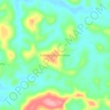
Name: Bampum Lakenakwa topographic map, elevation, terrain.
Location: Bampum Lakenakwa, Kwilu, Democratic Republic of the Congo (-4.30936 19.55897 -4.26936 19.59897)
Average elevation: 412 m
Minimum elevation: 372 m
Maximum elevation: 503 m
Other topographic maps
Click on a map to view its topography, its elevation and its terrain.
Penanga
Democratic Republic of the Congo > Kwilu > Kwilu
Penanga, Kwilu, Democratic Republic of the Congo
Average elevation: 458 m
Kinsangani
Democratic Republic of the Congo > Kwilu > Kwilu
Kinsangani, Kwilu, Democratic Republic of the Congo
Average elevation: 392 m
Kikwit
Democratic Republic of the Congo > Kwilu > Kwilu > Kikwit
Kikwit, Kwilu, Democratic Republic of the Congo
Average elevation: 459 m
Mulashi
Democratic Republic of the Congo > Kwilu > Kwilu > Mulashi
Mulashi, Kwilu, Democratic Republic of the Congo
Average elevation: 466 m