
Make a donation
Gear up for your next adventure:
As an Amazon Associate, this site earns from qualifying purchases at no extra cost to you.
Niota topographic map
Click on the map to display elevation.
Make a donation
Gear up for your next adventure:
As an Amazon Associate, this site earns from qualifying purchases at no extra cost to you.
About this map
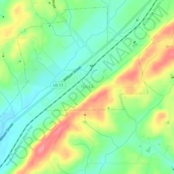
Name: Niota topographic map, elevation, terrain.
Location: Niota, McMinn County, Tennessee, 37926, United States (35.49842 -84.56946 35.52812 -84.53001)
Average elevation: 315 m
Minimum elevation: 280 m
Maximum elevation: 369 m
Make a donation
Gear up for your next adventure:
As an Amazon Associate, this site earns from qualifying purchases at no extra cost to you.
Other topographic maps
Click on a map to view its topography, its elevation and its terrain.
Make a donation
Gear up for your next adventure:
As an Amazon Associate, this site earns from qualifying purchases at no extra cost to you.
Make a donation
Gear up for your next adventure:
As an Amazon Associate, this site earns from qualifying purchases at no extra cost to you.
Athens
United States > Tennessee > McMinn County > Athens
The Cherokee were living in McMinn County at the time of the arrival of the first Euro-American explorers. The Athens area was situated nearly halfway between the Overhill Cherokee villages of Great Tellico to the north in Monroe County and Great Hiwassee along the Hiwassee River to the south. In 1819, the…
Average elevation: 287 m