
Thank you for supporting this site ❤️
Make a donation
Make a donation
Gear up for your next adventure:
As an Amazon Associate, this site earns from qualifying purchases at no extra cost to you.
Bausone topographic map
Click on the map to display elevation.
Thank you for supporting this site ❤️
Make a donation
Make a donation
Gear up for your next adventure:
As an Amazon Associate, this site earns from qualifying purchases at no extra cost to you.
About this map
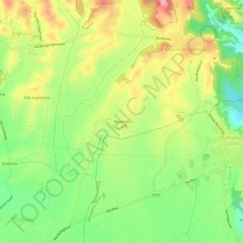
Name: Bausone topographic map, elevation, terrain.
Location: Bausone, Moriondo Torinese, Torino, Piemonte, 14024, Italia (45.00574 7.90491 45.04574 7.94491)
Average elevation: 291 m
Minimum elevation: 233 m
Maximum elevation: 357 m
Thank you for supporting this site ❤️
Make a donation
Make a donation
Gear up for your next adventure:
As an Amazon Associate, this site earns from qualifying purchases at no extra cost to you.