Geolocate

South Valley State Forest topographic map

Interactive map

Click on the map to display elevation.

About this map

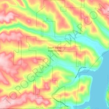
Name: South Valley State Forest topographic map, elevation, terrain.

Location: South Valley State Forest, Elk Township, Town of South Valley, Cattaraugus County, New York, United States (41.99898 -79.03968 42.07964 -78.96811)

Average elevation: 525 m

Minimum elevation: 398 m

Maximum elevation: 665 m

Other topographic maps

Click on a map to view its topography, its elevation and its terrain.

Village of Ellicottville

United States > New York > Cattaraugus County

Village of Ellicottville, Town of Ellicottville, Cattaraugus County, New York, 14731, United States

Average elevation: 524 m

City of Salamanca

United States > New York > Cattaraugus County

City of Salamanca, Cattaraugus County, New York, 14779, United States

Average elevation: 505 m

Town of Otto

United States > New York > Cattaraugus County

Town of Otto, Mansfield, Cattaraugus County, New York, 14766, United States

Average elevation: 425 m

West Valley

United States > New York > Cattaraugus County

West Valley, Town of Ashford, Cattaraugus County, New York, United States

Average elevation: 522 m

Village of South Dayton

United States > New York > Cattaraugus County > Town of Dayton

Village of South Dayton, Town of Dayton, Cattaraugus County, New York, United States

Average elevation: 404 m