
Σουληνάρι topographic map
Interactive map
Click on the map to display elevation.
About this map
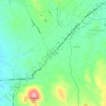
Name: Σουληνάρι topographic map, elevation, terrain.
Average elevation: 354 m
Minimum elevation: 255 m
Maximum elevation: 602 m
Other topographic maps
Click on a map to view its topography, its elevation and its terrain.
Φοινίκη
Griechenland > Peloponnes, Westgriechenland und Ionische Inseln > Regionalbezirk Messenien > Δημοτική Ενότητα Μεθώνης
Φοινίκη, Δημοτική Ενότητα Μεθώνης, Δήμος Πύλου - Νέστορος, Regionalbezirk Messenien, Region Peloponnes, Peloponnes, Westgriechenland und Ionische Inseln, 240 06, Griechenland
Average elevation: 83 m
Marathopoli
Griechenland > Peloponnes, Westgriechenland und Ionische Inseln > Regionalbezirk Messenien > Δημοτική Ενότητα Γαργαλιάνων
Marathopoli, Δημοτική Ενότητα Γαργαλιάνων, Δήμος Τριφυλίας, Regionalbezirk Messenien, Region Peloponnes, Peloponnes, Westgriechenland und Ionische Inseln, 244 00, Griechenland
Average elevation: 18 m
Μαντζάρι
Griechenland > Peloponnes, Westgriechenland und Ionische Inseln > Regionalbezirk Messenien
Μαντζάρι, Δήμος Οιχαλίας, Regionalbezirk Messenien, Region Peloponnes, Peloponnes, Westgriechenland und Ionische Inseln, 240 02, Griechenland
Average elevation: 78 m
Ρωμανός
Griechenland > Peloponnes, Westgriechenland und Ionische Inseln > Regionalbezirk Messenien > Πετροχώρι
Ρωμανός, Πετροχώρι, Δήμος Πύλου - Νέστορος, Regionalbezirk Messenien, Region Peloponnes, Peloponnes, Westgriechenland und Ionische Inseln, 240 01, Griechenland
Average elevation: 6 m
Παπαφλέσσας
Griechenland > Peloponnes, Westgriechenland und Ionische Inseln > Regionalbezirk Messenien
Παπαφλέσσας, Δήμος Πύλου - Νέστορος, Regionalbezirk Messenien, Region Peloponnes, Peloponnes, Westgriechenland und Ionische Inseln, 240 14, Griechenland
Average elevation: 532 m
Ίκλαινα
Griechenland > Peloponnes, Westgriechenland und Ionische Inseln > Regionalbezirk Messenien
Ίκλαινα, Δήμος Πύλου - Νέστορος, Regionalbezirk Messenien, Region Peloponnes, Peloponnes, Westgriechenland und Ionische Inseln, 240 01, Griechenland
Average elevation: 200 m
Βάλτα
Griechenland > Peloponnes, Westgriechenland und Ionische Inseln > Regionalbezirk Messenien > Δημοτική Ενότητα Γαργαλιάνων
Βάλτα, Δημοτική Ενότητα Γαργαλιάνων, Δήμος Τριφυλίας, Regionalbezirk Messenien, Region Peloponnes, Peloponnes, Westgriechenland und Ionische Inseln, 244 00, Griechenland
Average elevation: 218 m
Gargaliani
Griechenland > Peloponnes, Westgriechenland und Ionische Inseln > Regionalbezirk Messenien > Δημοτική Ενότητα Γαργαλιάνων
Gargaliani, Δημοτική Ενότητα Γαργαλιάνων, Δήμος Τριφυλίας, Regionalbezirk Messenien, Region Peloponnes, Peloponnes, Westgriechenland und Ionische Inseln, 244 00, Griechenland
Average elevation: 193 m
Floka
Griechenland > Peloponnes, Westgriechenland und Ionische Inseln > Regionalbezirk Messenien > Δημοτική Ενότητα Γαργαλιάνων
Floka, Δημοτική Ενότητα Γαργαλιάνων, Δήμος Τριφυλίας, Regionalbezirk Messenien, Region Peloponnes, Peloponnes, Westgriechenland und Ionische Inseln, 244 00, Griechenland
Average elevation: 334 m
Koroni
Griechenland > Peloponnes, Westgriechenland und Ionische Inseln > Regionalbezirk Messenien > Δημοτική Ενότητα Κορώνης
Koroni, Δημοτική Ενότητα Κορώνης, Δήμος Πύλου - Νέστορος, Regionalbezirk Messenien, Region Peloponnes, Peloponnes, Westgriechenland und Ionische Inseln, 240 04, Griechenland
Average elevation: 27 m
Πύργος
Griechenland > Peloponnes, Westgriechenland und Ionische Inseln > Regionalbezirk Messenien > Δημοτική Ενότητα Λεύκτρου > Νεοχώρι
Πύργος, Νεοχώρι, Δημοτική Ενότητα Λεύκτρου, Δήμος Δυτικής Μάνης, Regionalbezirk Messenien, Region Peloponnes, Peloponnes, Westgriechenland und Ionische Inseln, 240 24, Griechenland
Average elevation: 253 m
Kalamata
Griechenland > Peloponnes, Westgriechenland und Ionische Inseln > Regionalbezirk Messenien > Kalamata
Kalamata, Regionalbezirk Messenien, Region Peloponnes, Peloponnes, Westgriechenland und Ionische Inseln, Griechenland
Average elevation: 490 m