
Riosucio topographic map
Interactive map
Click on the map to display elevation.
Riosucio
The municipality is located in the west of the department. It is bounded by the municipality of Supía to the east, the municipality of Filadelfia to the south-east, the department of Risaralda to the south and west, and the department of Antioquia to the north. The total area of the municipality is 429.1 km2. The town of Riosucio lies at an altitude of 1783 meters above sea level, 91 km west of the departmental capital Manizales.
About this map
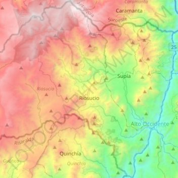
Name: Riosucio topographic map, elevation, terrain.
Location: Riosucio, Alto Occidente, Caldas, Colombia (5.33586 -75.86740 5.56355 -75.60966)
Average elevation: 1,899 m
Minimum elevation: 631 m
Maximum elevation: 3,250 m
Other topographic maps
Click on a map to view its topography, its elevation and its terrain.
Manizales
Manizales is the capital city of one of the smallest Colombian departments. The city is described as having an "abrupt topography", and lies on the Colombian Central Mountain Range (part of the longest continental mountain range, the Andes), with a great deal of ridgelines and steep slopes, which, combined…
Average elevation: 2,114 m
Manizales
Manizales is the capital city of one of the smallest Colombian departments. The city is described as having an "abrupt topography", and lies on the Colombian Central Mountain Range (part of the longest continental mountain range, the Andes), with a great deal of ridgelines and steep slopes, which, combined…
Average elevation: 2,010 m
Nevado del Ruiz
The summit of the volcano has steep slopes inclining from 20 to 30 degrees. At lower elevations, the slopes become less steep; their inclination is about 10 degrees. From there on, foothills stretch almost to the edge of the Magdalena River, north of the volcano and the Cauca River to the west. On the two…
Average elevation: 5,051 m
Manizales
Manizales is the capital city of one of the smallest Colombian departments. The city is described as having an "abrupt topography", and lies on the Colombian Central Mountain Range (part of the longest continental mountain range, the Andes), with a great deal of ridgelines and steep slopes, which, combined…
Average elevation: 1,933 m