
Sudd topographic map
Interactive map
Click on the map to display elevation.
Sudd
The morphology of the area is defined by the channel and lagoon system of the permanent Sudd swamps, the adjacent flood plains, and the surrounding flat terrain. The Bahr al Jabal runs to the north-northwest and therefore in an angle to the gradient of the floodplain, which slopes down to the north, while north of Juba the river flows in an incised trough. The banks of this trough decrease in height from south to north with the Bahr al Jabal approaching Bor and ending in the Sudd flood plain just north of Bor on the eastern bank and towards Shambe on the western bank. In the southern part, the river meanders from side to side in the restraining trough in one or more channels, but further north the swamp is not limited by higher ground and the system of river channels becomes increasingly complex. The characteristics of the river with its network of channels and lagoons are distinguishable in satellite imagery and digital elevation models.
About this map
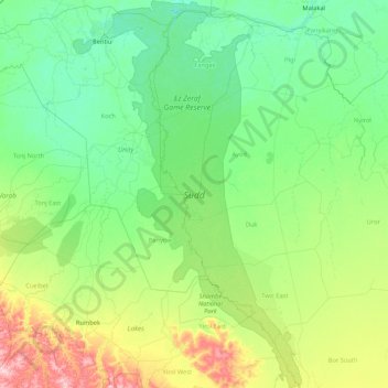
Name: Sudd topographic map, elevation, terrain.
Location: Sudd, Ayod, Jonglei, South Sudan (6.23337 29.54195 9.60203 31.55059)
Average elevation: 410 m
Minimum elevation: 388 m
Maximum elevation: 549 m