Geolocate

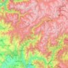
Jaboree topographic map

Click on the map to display elevation.

About this map

Name: Jaboree topographic map, elevation, terrain.

Location: Jaboree, Baffa Pakhal Tehsil, Mansehra District, Hazara Division, Khyber Pakhtunkhwa, Pakistan (34.58499 73.23907 34.62499 73.27907)

Average elevation: 1,610 m

Minimum elevation: 1,253 m

Maximum elevation: 2,142 m

Other topographic maps

Click on a map to view its topography, its elevation and its terrain.
Mansehra

Pakistan > Khyber Pakhtunkhwa > Mānsehra District

Average elevation: 1,091 m

Mansehra

Pakistan > Khyber Pakhtunkhwa > Mānsehra District

Average elevation: 1,091 m

Kaghan

Pakistan > Khyber Pakhtunkhwa > Mānsehra District

Average elevation: 2,464 m

Kaghan

Pakistan > Khyber Pakhtunkhwa > Mānsehra District

Average elevation: 2,464 m

Mansehra

Pakistan > Khyber Pakhtunkhwa > Mānsehra District

Average elevation: 1,091 m

Kaghan

Pakistan > Khyber Pakhtunkhwa > Mānsehra District

Average elevation: 2,464 m

Gear up for your next adventure:

📚UK Hiking Guidebooks - Detailed route descriptions for the Lake District, Peaks, and Highlands
🧥Packable Down Jackets - Lightweight warmth that compresses small in your bag
👟Men's Trail Running Shoes - Lightweight grip for fast movement over topographic contours
💧Hydration Reservoirs - Convenient water bladders for hands-free drinking on the move
🎒Replacement Sternum Straps - Repair parts for hiking rucksacks

As an Amazon Associate, this site earns from qualifying purchases at no extra cost to you.