
Fayetteville topographic map
Interactive map
Click on the map to display elevation.
About this map
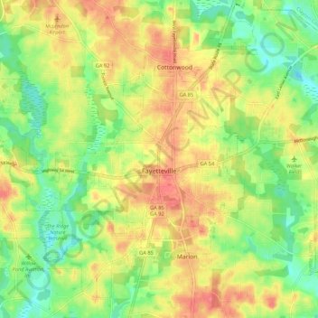
Name: Fayetteville topographic map, elevation, terrain.
Location: Fayetteville, Fayette County, Georgia, United States (33.41280 -84.52885 33.49112 -84.42163)
Average elevation: 265 m
Minimum elevation: 234 m
Maximum elevation: 295 m
Other topographic maps
Click on a map to view its topography, its elevation and its terrain.
Tamerlane
United States > Georgia > Fayette County > Peachtree City > Tamerlane
Average elevation: 247 m
Peachtree City
United States > Georgia > Fayette County
Shakerag Hill, with an elevation of 980 feet (300 m), is the highest point in the city and sits on the eastern border at the intersection of GA Hwy 54 and Robinson Road.
Average elevation: 262 m