
Lac Duval topographic map
Interactive map
Click on the map to display elevation.
About this map
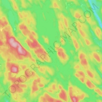
Name: Lac Duval topographic map, elevation, terrain.
Location: Lac Duval, Lac-Nilgaut, Pontiac, Outaouais, Québec, Canada (46.27258 -76.94536 46.35926 -76.86010)
Average elevation: 321 m
Minimum elevation: 226 m
Maximum elevation: 454 m
Other topographic maps
Click on a map to view its topography, its elevation and its terrain.
Lac Flater
Canada > Québec > Pontiac > Lac-Nilgaut
Lac Flater, Lac-Nilgaut, Pontiac, Outaouais, Québec, Canada
Average elevation: 326 m