
Alversjö topographic map
Interactive map
Click on the map to display elevation.
About this map
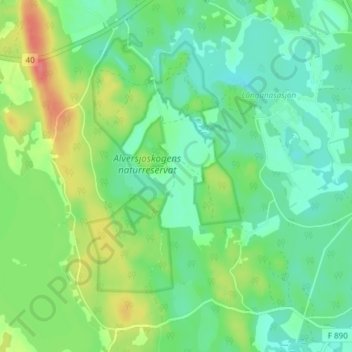
Name: Alversjö topographic map, elevation, terrain.
Location: Alversjö, Eksjö kommun, 575 96, Sweden (57.60057 14.90738 57.64057 14.94738)
Average elevation: 211 m
Minimum elevation: 191 m
Maximum elevation: 252 m
Other topographic maps
Click on a map to view its topography, its elevation and its terrain.
Ven
Sweden > Skåne County > Tuna
Along the entire coast, the island drops steeply towards the sea where the Öresund meets a rocky beach. This steep coast is called Backafall. Ven's backafall is a nature reserve established in 1990. There are no large forests, but smaller stands of trees occur closest to the coast the slightly higher…
Average elevation: 13 m
Ekerö kommun
Ekerö is the only municipality in the Lake Mälaren region composed exclusively of islands. Land elevation has reduced the number of islands and skerries to 140, the largest of which are Adelsö, Munsö, Ekerö, Färingsö, and Lovö. 2000 years ago, during the Roman Iron Age, Färingsön was more of an…
Average elevation: 20 m
Södermalm
Sweden > Stockholm County > Stockholm
The name Södermalm (as Suthaermalm) is first mentioned in 1288 in a letter from Bishop Anund of Strängnäs. Until the early 17th century Södermalm was mainly a rural, agricultural area. Its first urban areas were planned and built in the mid 17th century, comprising a mixture of working class housing, such…
Average elevation: 22 m