
Mangala topographic map
Interactive map
Click on the map to display elevation.
About this map
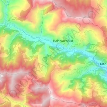
Name: Mangala topographic map, elevation, terrain.
Location: Mangala, Myagdi, Gandaki Province, Nepal (28.31914 83.38341 28.43984 83.51398)
Average elevation: 1,912 m
Minimum elevation: 887 m
Maximum elevation: 3,006 m
Other topographic maps
Click on a map to view its topography, its elevation and its terrain.
Annapurna I
Nepal > Gandaki Province > Myagdi
The mountain is named after Annapurna, the Hindu goddess of food and nourishment, who is said to reside there. The name Annapurna is derived from the Sanskrit-language words purna ("filled") and anna ("food"), and can be translated as "everlasting food". Many streams descending from the slopes of the Annapurna…
Average elevation: 7,126 m