
Make a donation
Gear up for your next adventure:
As an Amazon Associate, this site earns from qualifying purchases at no extra cost to you.
Dunmore topographic map
Click on the map to display elevation.
Make a donation
Gear up for your next adventure:
As an Amazon Associate, this site earns from qualifying purchases at no extra cost to you.
About this map
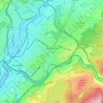
Name: Dunmore topographic map, elevation, terrain.
Average elevation: 312 m
Minimum elevation: 202 m
Maximum elevation: 606 m
Make a donation
Gear up for your next adventure:
As an Amazon Associate, this site earns from qualifying purchases at no extra cost to you.
Other topographic maps
Click on a map to view its topography, its elevation and its terrain.
Mount Cobb
United States > Pennsylvania > Lackawanna County > Jefferson Township
Average elevation: 529 m
Wimmers
United States > Pennsylvania > Lackawanna County > Jefferson Township > Mount Cobb
Average elevation: 495 m
Make a donation
Gear up for your next adventure:
As an Amazon Associate, this site earns from qualifying purchases at no extra cost to you.
Make a donation
Gear up for your next adventure:
As an Amazon Associate, this site earns from qualifying purchases at no extra cost to you.
Falling Springs Reservoir
United States > Pennsylvania > Lackawanna County > Ransom Township
Average elevation: 375 m
Pine Hill Vista
United States > Pennsylvania > Lackawanna County > Thornhurst Township
Average elevation: 628 m
Eagle Lake
United States > Pennsylvania > Lackawanna County > Covington Township
Average elevation: 578 m
Birchwood Estates
United States > Pennsylvania > Lackawanna County > Roaring Brook Township
Average elevation: 512 m
Make a donation
Gear up for your next adventure:
As an Amazon Associate, this site earns from qualifying purchases at no extra cost to you.
Elmhurst
United States > Pennsylvania > Lackawanna County > Elmhurst Township
Average elevation: 478 m
Spring Brook
United States > Pennsylvania > Lackawanna County > Spring Brook Township
Average elevation: 463 m
Madisonville
United States > Pennsylvania > Lackawanna County > Madison Township
Average elevation: 512 m
Make a donation
Gear up for your next adventure:
As an Amazon Associate, this site earns from qualifying purchases at no extra cost to you.
Mount Cobb
United States > Pennsylvania > Lackawanna County > Jefferson Township
Average elevation: 529 m
Make a donation
Gear up for your next adventure:
As an Amazon Associate, this site earns from qualifying purchases at no extra cost to you.
Make a donation
Gear up for your next adventure:
As an Amazon Associate, this site earns from qualifying purchases at no extra cost to you.