
Make a donation
Gear up for your next adventure:
As an Amazon Associate, this site earns from qualifying purchases at no extra cost to you.
Mount Pandadagsaan topographic map
Click on the map to display elevation.
Make a donation
Gear up for your next adventure:
As an Amazon Associate, this site earns from qualifying purchases at no extra cost to you.
Mount Pandadagsaan
Mount Tagubud, also known as Mount Pandadagsaan or White Peak, is the highest mountain in the province of Davao de Oro in the Philippines with an elevation of 2,650 metres (8,694 ft) above sea level. Located in New Bataan Davao de Oro, Davao Region in the island of Mindanao Philippines, Mount Tagubud is the source of the Agusan River.
Make a donation
Gear up for your next adventure:
As an Amazon Associate, this site earns from qualifying purchases at no extra cost to you.
About this map
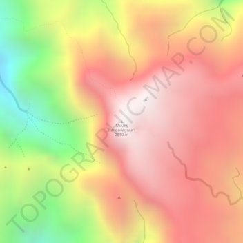
Name: Mount Pandadagsaan topographic map, elevation, terrain.
Average elevation: 2,195 m
Minimum elevation: 1,462 m
Maximum elevation: 2,637 m
Make a donation
Gear up for your next adventure:
As an Amazon Associate, this site earns from qualifying purchases at no extra cost to you.
Other topographic maps
Click on a map to view its topography, its elevation and its terrain.