
Make a donation
Gear up for your next adventure:
As an Amazon Associate, this site earns from qualifying purchases at no extra cost to you.
Tawang district topographic map
Click on the map to display elevation.
Make a donation
Gear up for your next adventure:
As an Amazon Associate, this site earns from qualifying purchases at no extra cost to you.
Tawang district
Tawang district occupies an area of 2,172 square kilometres (839 sq mi),. The district is roughly located around latitude 27° 45’ N and longitude 90° 15’ E at the northwest extremity of South Tibet. Elevations range between 6,000 and 22,000 feet (6,700 m), and inhabitants are found at lower altitude, where they enjoy a cool temperate climate.
Make a donation
Gear up for your next adventure:
As an Amazon Associate, this site earns from qualifying purchases at no extra cost to you.
About this map
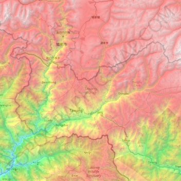
Name: Tawang district topographic map, elevation, terrain.
Location: Tawang district, Arunachal Pradesh, India (27.45982 91.56231 27.88775 92.45600)
Average elevation: 3,767 m
Minimum elevation: 798 m
Maximum elevation: 6,403 m
Make a donation
Gear up for your next adventure:
As an Amazon Associate, this site earns from qualifying purchases at no extra cost to you.
Other topographic maps
Click on a map to view its topography, its elevation and its terrain.
Make a donation
Gear up for your next adventure:
As an Amazon Associate, this site earns from qualifying purchases at no extra cost to you.
Make a donation
Gear up for your next adventure:
As an Amazon Associate, this site earns from qualifying purchases at no extra cost to you.
Make a donation
Gear up for your next adventure:
As an Amazon Associate, this site earns from qualifying purchases at no extra cost to you.
Tawang
India > Arunachal Pradesh > Tawang Circle
Tawang is situated 448 km north-west of state capital Itanagar at an elevation of approximately 3,048 metres (10,000 ft). It lies to the north of the Tawang Chu river valley, roughly 10 miles (16 km) south of the Line of Actual Control with China. It is the site of a famous Gelugpa Buddhist monastery.
Average elevation: 3,280 m
Make a donation
Gear up for your next adventure:
As an Amazon Associate, this site earns from qualifying purchases at no extra cost to you.
Make a donation
Gear up for your next adventure:
As an Amazon Associate, this site earns from qualifying purchases at no extra cost to you.
Make a donation
Gear up for your next adventure:
As an Amazon Associate, this site earns from qualifying purchases at no extra cost to you.
Khonsa
India > Arunachal Pradesh > Khonsa HQ
Khonsa is located at 27°01′N 95°34′E / 27.02°N 95.57°E / 27.02; 95.57. It has an average elevation of 1215 metres (3986 feet).
Average elevation: 858 m
Make a donation
Gear up for your next adventure:
As an Amazon Associate, this site earns from qualifying purchases at no extra cost to you.
Sessa Orchid Sanctuary
India > Arunachal Pradesh > Bhalukpong EAC
Sessa sanctuary is drained by the Tippi Naala (Tippi river), which joins the Kameng river at Tippi village on the Bhalukpong-Bomdila highway. Topographic map
Average elevation: 1,414 m
Make a donation
Gear up for your next adventure:
As an Amazon Associate, this site earns from qualifying purchases at no extra cost to you.
Make a donation
Gear up for your next adventure:
As an Amazon Associate, this site earns from qualifying purchases at no extra cost to you.
Make a donation
Gear up for your next adventure:
As an Amazon Associate, this site earns from qualifying purchases at no extra cost to you.
Naharlagun
India > Arunachal Pradesh > Naharlagun EAC
It is at an altitude of 155 metres from sea level.[citation needed] Surrounded by mountains, Naharlagun is a city which sees annual long monsoon rains. The weather is sub-tropical, with hot and humid summer and temperate winter.
Average elevation: 255 m
Make a donation
Gear up for your next adventure:
As an Amazon Associate, this site earns from qualifying purchases at no extra cost to you.
Sangdupota (Basar Nello)
India > Arunachal Pradesh > Sangdupota Basar Nello Circle
Average elevation: 372 m
Make a donation
Gear up for your next adventure:
As an Amazon Associate, this site earns from qualifying purchases at no extra cost to you.