Geolocate

Magnolia topographic map

Click on the map to display elevation.

About this map

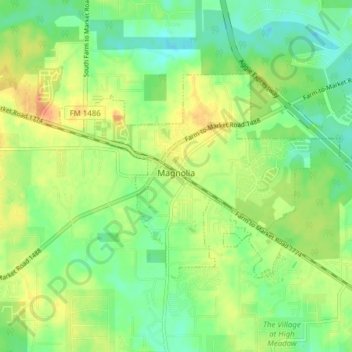
Name: Magnolia topographic map, elevation, terrain.

Location: Magnolia, Montgomery County, Texas, 77353, United States (30.18961 -95.77650 30.22826 -95.69937)

Average elevation: 77 m

Minimum elevation: 58 m

Maximum elevation: 102 m

Other topographic maps

Click on a map to view its topography, its elevation and its terrain.

Bobville

United States > Texas > Montgomery County

Average elevation: 75 m

New Caney

United States > Texas > Montgomery County

Average elevation: 30 m

Mount Zion

United States > Texas > Montgomery County

Average elevation: 88 m

Security

United States > Texas > Montgomery County

Average elevation: 53 m

Conroe

United States > Texas > Montgomery County > Conroe > Conroe

Average elevation: 60 m

Porter

United States > Texas > Montgomery County

Average elevation: 30 m

Lake Egypt

United States > Texas > Montgomery County > Egypt

Average elevation: 61 m

New Caney

United States > Texas > Montgomery County

Average elevation: 30 m

Gear up for your next adventure:

🔋Solar Chargers - Eco-friendly charging solutions for outdoor use
👖Hiking Trousers - Durable trousers designed for rough terrain
🌄Outdoor Binoculars - Compact binoculars for landscape observation
🥾Hiking Boot Waterproofing Wax - Maintain the lifespan of your leather trekking boots
🧦Merino Wool Hiking Socks - Moisture-wicking socks to prevent blisters during long mountain walks

As an Amazon Associate, this site earns from qualifying purchases at no extra cost to you.