
Make a donation
Gear up for your next adventure:
As an Amazon Associate, this site earns from qualifying purchases at no extra cost to you.
Peru topographic map
Click on the map to display elevation.
Make a donation
Gear up for your next adventure:
As an Amazon Associate, this site earns from qualifying purchases at no extra cost to you.
About this map
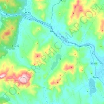
Name: Peru topographic map, elevation, terrain.
Location: Peru, Oxford County, Maine, 04290, United States (44.42162 -70.56062 44.53185 -70.34891)
Average elevation: 238 m
Minimum elevation: 111 m
Maximum elevation: 654 m
Make a donation
Gear up for your next adventure:
As an Amazon Associate, this site earns from qualifying purchases at no extra cost to you.
Other topographic maps
Click on a map to view its topography, its elevation and its terrain.
Sturtevant Pond
United States > Maine > Oxford County > Magalloway Plantation
Average elevation: 406 m
Mad River Falls
United States > Maine > Oxford County > Batchelders Grant Township
Average elevation: 495 m
Make a donation
Gear up for your next adventure:
As an Amazon Associate, this site earns from qualifying purchases at no extra cost to you.