Geolocate

Shere topographic map

Click on the map to display elevation.

About this map

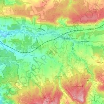
Name: Shere topographic map, elevation, terrain.

Location: Shere, Gomshall, Guildford, Surrey, England, United Kingdom (51.17319 -0.48014 51.24234 -0.40808)

Average elevation: 136 m

Minimum elevation: 46 m

Maximum elevation: 257 m

Surrey trails, hiking, mountain biking, running and outdoor activities

Other topographic maps

Click on a map to view its topography, its elevation and its terrain.

Fairlands

United Kingdom > England > Surrey > Guildford

Average elevation: 48 m

Guildford

United Kingdom > England > Surrey > Guildford

Average elevation: 64 m

Gatwick

United Kingdom > England > Surrey > Guildford

Average elevation: 64 m

Newlands Corner

United Kingdom > England > Surrey > Guildford > Albury

Average elevation: 121 m

Cooper's Hill

United Kingdom > England > Surrey > Guildford

Average elevation: 57 m

Guildford

United Kingdom > England > Surrey > Guildford

Average elevation: 64 m

Gear up for your next adventure:

🥾Trekking Poles - Poles to improve stability on uneven terrain
🧣Neck Gaiters - Versatile protection against wind and cold
🥼Base Layers - Thermal base layers for temperature regulation
🔋Solar Power Banks - Keep your GPS and phone charged during multi-day expeditions
🔥Reusable Hand Warmers - Maintain dexterity in your fingers for precise map handling

As an Amazon Associate, this site earns from qualifying purchases at no extra cost to you.