Geolocate

Talugtug topographic map

Click on the map to display elevation.

About this map

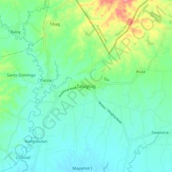
Name: Talugtug topographic map, elevation, terrain.

Location: Talugtug, Nueva Ecija, Central Luzon, 3118, Philippines (15.73807 120.76804 15.81807 120.84804)

Average elevation: 82 m

Minimum elevation: 50 m

Maximum elevation: 183 m

Other topographic maps

Click on a map to view its topography, its elevation and its terrain.

Cuyapo

Philippines > Nueva Ecija

Average elevation: 41 m

Peñaranda

Philippines > Nueva Ecija

Average elevation: 39 m

Aliaga

Philippines > Nueva Ecija

Average elevation: 26 m

Quezon

Philippines > Nueva Ecija

Average elevation: 28 m

Gear up for your next adventure:

🧵Survival Paracord - Multi-purpose cordage for emergency repairs and shelters
Insulated Travel Mugs - Keep drinks hot while surveying the landscape from a summit
🐕Hiking Dog Harnesses - Rugged harnesses for taking your companion on mountain trails
🧴Tick Removal Tools - Small, essential health tool for UK woodland and moorland
👖Convertible Hiking Trousers - Versatile zip-off pants for changing mountain weather conditions

As an Amazon Associate, this site earns from qualifying purchases at no extra cost to you.