
Make a donation
Gear up for your next adventure:
As an Amazon Associate, this site earns from qualifying purchases at no extra cost to you.
Khoy County topographic map
Click on the map to display elevation.
Make a donation
Gear up for your next adventure:
As an Amazon Associate, this site earns from qualifying purchases at no extra cost to you.
About this map
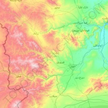
Name: Khoy County topographic map, elevation, terrain.
Location: Khoy County, West Azerbaijan Province, 58139-68197, Iran (38.31589 44.25407 38.97050 45.33560)
Average elevation: 1,824 m
Minimum elevation: 907 m
Maximum elevation: 3,600 m
Make a donation
Gear up for your next adventure:
As an Amazon Associate, this site earns from qualifying purchases at no extra cost to you.
Other topographic maps
Click on a map to view its topography, its elevation and its terrain.
Ali Kandi
Iran > West Azerbaijan Province > Urumia County > دهستان نازلوی جنوبی
Average elevation: 1,310 m
Make a donation
Gear up for your next adventure:
As an Amazon Associate, this site earns from qualifying purchases at no extra cost to you.
Dizaj-e Tavil
Iran > West Azerbaijan Province > Showt County > دهستان یولاگلدی
Average elevation: 987 m
Make a donation
Gear up for your next adventure:
As an Amazon Associate, this site earns from qualifying purchases at no extra cost to you.
Gabaran
Iran > West Azerbaijan Province > Urumia County > دهستان بکشلوچای > Lashenlu
Average elevation: 1,288 m
Make a donation
Gear up for your next adventure:
As an Amazon Associate, this site earns from qualifying purchases at no extra cost to you.
shiveh
Iran > West Azerbaijan Province > Salmas County > دهستان شناتال > shiveh
Average elevation: 2,160 m
Darin Qaleh
Iran > West Azerbaijan Province > Urumia County > دهستان باراندوزچای جنوبی > Darin Qaleh
Average elevation: 1,625 m
Make a donation
Gear up for your next adventure:
As an Amazon Associate, this site earns from qualifying purchases at no extra cost to you.
Shahindezh
Iran > West Azerbaijan Province > Shahin Dezh County > Shahin Dezh
Shahin Dezh is located about 1,300 meters in elevation. The city is on the Zarrineh River, southeast of Lake Urmia.
Average elevation: 1,418 m