Town of Worcester topographic map
Interactive map
Click on the map to display elevation.
About this map
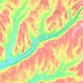
Name: Town of Worcester topographic map, elevation, terrain.
Location: Town of Worcester, Otsego County, New York, United States (42.50442 -74.78378 42.66185 -74.63084)
Average elevation: 553 m
Minimum elevation: 367 m
Maximum elevation: 740 m
Other topographic maps
Click on a map to view its topography, its elevation and its terrain.
Town of Hartwick
United States > New York > Otsego County
Town of Hartwick, Otsego County, New York, United States
Average elevation: 489 m
Town of Otego
United States > New York > Otsego County
Town of Otego, Otsego County, New York, 13825, United States
Average elevation: 453 m
Town of Maryland
United States > New York > Otsego County
Town of Maryland, Otsego County, New York, 12155, United States
Average elevation: 490 m
Lena
United States > New York > Otsego County > Town of New Lisbon
Lena, Town of New Lisbon, Otsego County, New York, 13810, United States
Average elevation: 455 m
Village of Cooperstown
United States > New York > Otsego County
Village of Cooperstown, Town of Otsego, Otsego County, New York, United States
Average elevation: 417 m