
Rhonetal topographic map
Interactive map
Click on the map to display elevation.
About this map
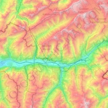
Name: Rhonetal topographic map, elevation, terrain.
Location: Rhonetal, Westlich Raron, Wallis, Schweiz (46.29669 7.56371 46.37596 8.09706)
Average elevation: 2,147 m
Minimum elevation: 549 m
Maximum elevation: 4,157 m
Other topographic maps
Click on a map to view its topography, its elevation and its terrain.
Sankt German
Schweiz > Wallis > Westlich Raron
Sankt German, Raron, Westlich Raron, Wallis, 3942, Schweiz
Average elevation: 1,010 m
Raron
Schweiz > Wallis > Westlich Raron
Raron, Westlich Raron, Wallis, 3942, Schweiz
Average elevation: 1,712 m