
Ersekë topographic map
Interactive map
Click on the map to display elevation.
Ersekë
Ersekë (Albanian definite form: Erseka), is a town and a former municipality in southeastern Albania. At the 2015 local government reform it became a subdivision and the seat of the municipality Kolonjë. Founded in the 17th century, Erseka was the seat of the former Kolonjë District. The population at the 2011 census was 3,746. Situated at the foot of the Gramos mountains, it is a small alpine town at 1050 meters in altitude, making it one of the highest towns in Albania.
About this map
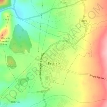
Name: Ersekë topographic map, elevation, terrain.
Average elevation: 1,018 m
Minimum elevation: 949 m
Maximum elevation: 1,096 m
Other topographic maps
Click on a map to view its topography, its elevation and its terrain.
Zvarisht
Albania > Southern Albania > Korçë County > Bashkia Maliq > Zvarisht
Average elevation: 959 m
Kuç i Zi
Albania > Southern Albania > Korçë County > Bashkia Korçë > Kuç i Zi
Average elevation: 986 m