
Town of Wawayanda topographic map
Interactive map
Click on the map to display elevation.
About this map
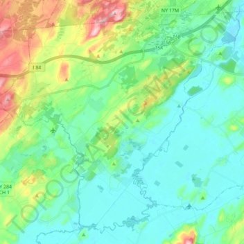
Name: Town of Wawayanda topographic map, elevation, terrain.
Location: Town of Wawayanda, Orange County, New York, United States (41.31351 -74.54562 41.43104 -74.37357)
Average elevation: 156 m
Minimum elevation: 109 m
Maximum elevation: 303 m
Other topographic maps
Click on a map to view its topography, its elevation and its terrain.
Cornwall Landing
United States > New York > Orange County > Village of Cornwall-on-Hudson
Average elevation: 74 m
Nathaniel Wetlands Inventory - R5UBH - 0.09 acres
United States > New York > Orange County
Average elevation: 138 m