
Alt St. Johann topographic map
Interactive map
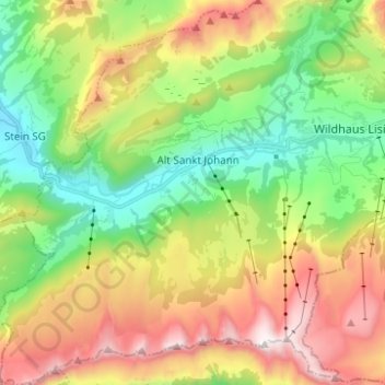
Click on the map to display elevation.
About this map
Name: Alt St. Johann topographic map, elevation, terrain.
Average elevation: 1,424 m
Minimum elevation: 830 m
Maximum elevation: 2,306 m
Alt St. Johann und das damals zugehörige Dorf Unterwasser blicken auf eine lange touristische Tradition zurück, so wurde bereits 1934 die Standseilbahn zum Iltios gebaut, der seither zahlreiche weitere Transportanlagen folgten. Heute gehört Alt St. Johann mit Wildhaus und Unterwasser zum Skigebiet Obertoggenburg, das auf dem Chäserrugg eine Höhe von 2262 m erreicht. Seit 2019 ist das Ski- und Sommersportgebiet wegen des «Bergbahnstreits» in die Gebiete Alt St. Johann/Unterwasser und Wildhaus getrennt. Im Sommer und Winter ist es Ausgangspunkt für Wanderungen und Skitouren zum Säntis wie auch zu den Churfirsten.
Other topographic maps
Click on a map to view its topography, its elevation and its terrain.
Säntis
Schweiz > St. Gallen > Wahlkreis Toggenburg > Wildhaus-Alt St. Johann
Säntis, Wildhaus-Alt St. Johann, Wahlkreis Toggenburg, St. Gallen, 9658, Schweiz
Average elevation: 1,933 m