Geolocate

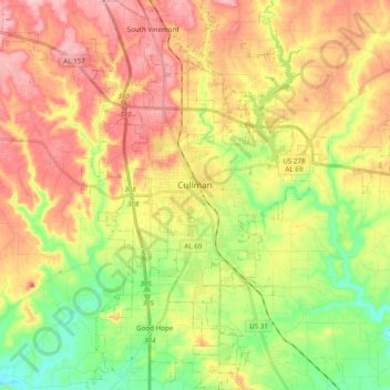
Cullman topographic map

Click on the map to display elevation.

Cullman

Cullman is located on top of the Brindley Mountain plateau at 34°10′39″N 86°50′42″W / 34.17750°N 86.84500°W / 34.17750; -86.84500 (34.177508, −86.844996). This is a close offshoot of the long geographic ridge called Sand Mountain, a southmost extension of the Appalachian Mountains. The elevation is 826 feet (252 m), close to the watershed between the Tennessee River and the Black Warrior River. Cullman provides its own town water supply from a city-owned lake within the city limits, Lake Catoma.

Wikipedia (CC-BY-SA 3.0)

About this map

Name: Cullman topographic map, elevation, terrain.

Location: Cullman, Cullman County, Alabama, United States (34.09015 -86.90025 34.25071 -86.77715)

Average elevation: 239 m

Minimum elevation: 159 m

Maximum elevation: 321 m

Other topographic maps

Click on a map to view its topography, its elevation and its terrain.
Joppa

United States > Alabama > Cullman County

Average elevation: 308 m

Arkadelphia

United States > Alabama > Cullman County

Average elevation: 129 m

Duck River

United States > Alabama > Cullman County

Average elevation: 235 m

Crane Hill

United States > Alabama > Cullman County

Average elevation: 215 m

Trimble

United States > Alabama > Cullman County

Average elevation: 185 m

Hanceville

United States > Alabama > Cullman County > Hanceville

Average elevation: 178 m

Gear up for your next adventure:

🧥Packable Down Jackets - Lightweight warmth that compresses small in your bag
📦Dry Bags - Waterproof bags to protect gear from rain
🗺️Ordnance Survey Maps - Official UK maps for walking and outdoor activities
🦯Walking Poles - Supportive poles for long-distance walking
🔋Lithium AA Batteries - Long-lasting power that performs well in cold mountain weather

As an Amazon Associate, this site earns from qualifying purchases at no extra cost to you.