
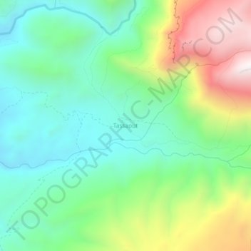
Tassaout topographic map
Interactive map
Click on the map to display elevation.
About this map
Name: Tassaout topographic map, elevation, terrain.
Average elevation: 2,682 m
Minimum elevation: 2,313 m
Maximum elevation: 3,430 m
Other topographic maps
Click on a map to view its topography, its elevation and its terrain.
Jebel M'Goun
Maroc > cercle d'Ouarzazate > Imi N'Oulaoune
Jebel M'Goun, Imi N'Oulaoune, caïdat de Moghrane, cercle d'Ouarzazate, Province de Ouarzazate, Drâa-Tafilalet, Maroc
Average elevation: 3,689 m