
Thank you for supporting this site ❤️
Make a donation
Make a donation
Gear up for your next adventure:
As an Amazon Associate, this site earns from qualifying purchases at no extra cost to you.
Pallivasal topographic map
Click on the map to display elevation.
Thank you for supporting this site ❤️
Make a donation
Make a donation
Gear up for your next adventure:
As an Amazon Associate, this site earns from qualifying purchases at no extra cost to you.
About this map
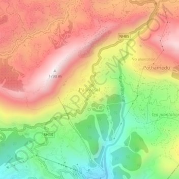
Name: Pallivasal topographic map, elevation, terrain.
Location: Pallivasal, Devikulam, Idukki, Kerala, 685565, India (10.02978 77.03148 10.06978 77.07148)
Average elevation: 1,305 m
Minimum elevation: 818 m
Maximum elevation: 1,755 m
Thank you for supporting this site ❤️
Make a donation
Make a donation
Gear up for your next adventure:
As an Amazon Associate, this site earns from qualifying purchases at no extra cost to you.