Geolocate

Uran topographic map

Click on the map to display elevation.

Uran

Uran is located at 18°53′N 72°56′E / 18.88°N 72.94°E / 18.88; 72.94. Uran is at an average elevation of 21 metres (69 ft).

Wikipedia (CC-BY-SA 3.0)

About this map

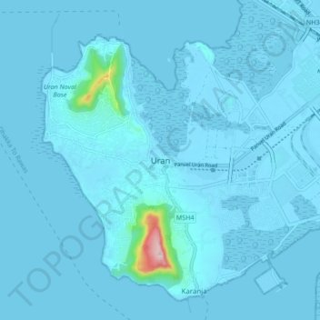
Name: Uran topographic map, elevation, terrain.

Location: Uran, Uran Subdistrict, Raigad, Maharashtra, 400702, India (18.84080 72.89860 18.92080 72.97860)

Average elevation: 10 m

Minimum elevation: -4 m

Maximum elevation: 299 m

Gear up for your next adventure:

📦Compression Sacks - Reduce backpack volume efficiently
🧷Tenacious Repair Tape - Instant fix for torn tents, jackets, or dry bags
🥾Hiking Boot Waterproofing Wax - Maintain the lifespan of your leather trekking boots
🧢Thermal Beanie Hats - Prevent heat loss from the head in windy summit conditions
👟Women's Trail Running Shoes - Agile footwear for fell running and technical trails

As an Amazon Associate, this site earns from qualifying purchases at no extra cost to you.