
Make a donation
Gear up for your next adventure:
As an Amazon Associate, this site earns from qualifying purchases at no extra cost to you.
Wuustwezel topographic map
Click on the map to display elevation.
Make a donation
Gear up for your next adventure:
As an Amazon Associate, this site earns from qualifying purchases at no extra cost to you.
Wuustwezel
Wuustwezel ligt in de Noorderkempen op een hoogte van 15-25 meter. Waterlopen zijn de Kleine Beek die via de Kleine Aa in de Aa of Weerijs uitmondt. Een belangrijk natuurgebied met heide en vennen is het Groot Schietveld, ten zuiden van Wuustwezel. Een ander natuurgebied is het Uilebos.
Make a donation
Gear up for your next adventure:
As an Amazon Associate, this site earns from qualifying purchases at no extra cost to you.
About this map
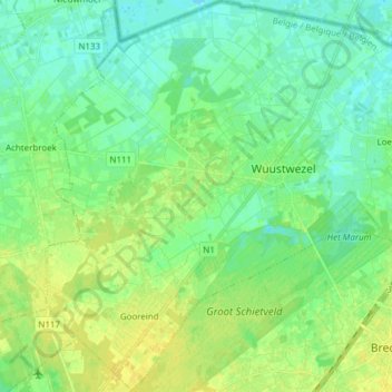
Name: Wuustwezel topographic map, elevation, terrain.
Location: Wuustwezel, Antwerpen, Vlaanderen, België (51.33757 4.50630 51.43285 4.64132)
Average elevation: 19 m
Minimum elevation: 11 m
Maximum elevation: 28 m
Make a donation
Gear up for your next adventure:
As an Amazon Associate, this site earns from qualifying purchases at no extra cost to you.
Other topographic maps
Click on a map to view its topography, its elevation and its terrain.