
Thank you for supporting this site ❤️
Make a donation
Make a donation
Gear up for your next adventure:
As an Amazon Associate, this site earns from qualifying purchases at no extra cost to you.
Vattakanal topographic map
Click on the map to display elevation.
Thank you for supporting this site ❤️
Make a donation
Make a donation
Gear up for your next adventure:
As an Amazon Associate, this site earns from qualifying purchases at no extra cost to you.
About this map
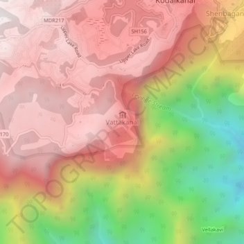
Name: Vattakanal topographic map, elevation, terrain.
Location: Vattakanal, Kodaikanal, Dindigul, Tamil Nadu, 624100, Inde (10.19507 77.46497 10.23507 77.50497)
Average elevation: 1,776 m
Minimum elevation: 864 m
Maximum elevation: 2,337 m
Thank you for supporting this site ❤️
Make a donation
Make a donation
Gear up for your next adventure:
As an Amazon Associate, this site earns from qualifying purchases at no extra cost to you.