
Make a donation
Gear up for your next adventure:
As an Amazon Associate, this site earns from qualifying purchases at no extra cost to you.
Kongur Tagh topographic map
Click on the map to display elevation.
Make a donation
Gear up for your next adventure:
As an Amazon Associate, this site earns from qualifying purchases at no extra cost to you.
Kongur Tagh
Kongur Tagh (Kyrgyz: Коңур Тоо; Uyghur: قوڭۇر تاغ, Коңур Тағ, meaning "Brown Mountain"; Mongolian: Хонгор Таг, (Хонгор/Kongur/Kongur is Mongolian word for the color Mongolians use for Buckskin colored horse) Hongor Tag; simplified Chinese: 公格尔峰; traditional Chinese: 公格爾峰; pinyin: Gōnggé'ěr Fēng; also referred to as Kongur) is the highest peak in the Pamir Mountains, and also the highest mountain wholly within the Xinjiang Uyghur Autonomous Region, China. With an elevation of 7,649 metres (25,095 ft), it is also the highest mountain outside of the Hindu Kush/Karakoram and Himalaya ranges.
Make a donation
Gear up for your next adventure:
As an Amazon Associate, this site earns from qualifying purchases at no extra cost to you.
About this map
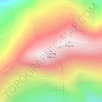
Name: Kongur Tagh topographic map, elevation, terrain.
Average elevation: 6,904 m
Minimum elevation: 5,862 m
Maximum elevation: 7,645 m
Make a donation
Gear up for your next adventure:
As an Amazon Associate, this site earns from qualifying purchases at no extra cost to you.
Other topographic maps
Click on a map to view its topography, its elevation and its terrain.