
Styhead Tarn topographic map
Click on the map to display elevation.
About this map
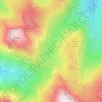
Name: Styhead Tarn topographic map, elevation, terrain.
Location: Styhead Tarn, Borrowdale, Cumberland, England, United Kingdom (54.47715 -3.20392 54.47902 -3.20143)
Average elevation: 525 m
Minimum elevation: 160 m
Maximum elevation: 904 m
Cumberland trails, hiking, mountain biking, running and outdoor activities
Other topographic maps
Click on a map to view its topography, its elevation and its terrain.
Brund Fell (summit)
United Kingdom > England > Cumberland > Borrowdale
The fell has a summit plateau which consist of many heather-covered hummocks, drystone walls and clumps of trees. Well-known Lake District writer Alfred Wainwright credits Grange Fell as a single fell with three main summits, namely Brund Fell, King's How and Ether Knott. The lesser known Ether Knott is now…
Average elevation: 252 m
Seathwaite Fell (Wainwright)
United Kingdom > England > Cumberland > Borrowdale
Average elevation: 511 m
Castle Crag
United Kingdom > England > Cumberland > Borrowdale
The wooded height of Castle Crag rises between Broadslack Gill and the Derwent, the two streams meeting to the north beneath the outlying knoll of Low Hows. It has steep faces on all sides except the south, where a low ridge runs out and then swings west around the head of Broadslack Gill. A narrow col here…
Average elevation: 272 m