
Make a donation
Gear up for your next adventure:
As an Amazon Associate, this site earns from qualifying purchases at no extra cost to you.
Amol topographic map
Click on the map to display elevation.
Make a donation
Gear up for your next adventure:
As an Amazon Associate, this site earns from qualifying purchases at no extra cost to you.
Amol
Amol is located on the banks of the Haraz River (26 25'N 52 21'E) at an altitude of 76 m above the sea. It is about 18 km from the Caspian Sea and about 10 km from the northern Alborz mountains. It is 180 km from the Iranian capital, Tehran, with a picturesque drive through Haraz Road. Sari, the capital of Mazandaran, is 70 km east of Amol. Mount Damavand (5610 m), the highest peak in the Middle East, is located south of Amol. Amol, with its elevated landscape and valleys, has dense forests. Its tall hills overlook the plains and stretch out to the high slopes of the Mount Damavand. The majestic and deep rocky valleys, rivers, numerous springs, elevated waterfalls, colorful vegetation, a variety of wild life, thermal springs, summer quarters, and rural settlements are some of the special factors which can prove attractive. The city has Mediterranean climate with very hot summers and cool and humid winters. Maximum rainfall is usually in the month of December and minimum in the month of July.
Make a donation
Gear up for your next adventure:
As an Amazon Associate, this site earns from qualifying purchases at no extra cost to you.
About this map
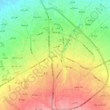
Name: Amol topographic map, elevation, terrain.
Location: Amol, بخش مرکزی, Amol County, Mazandaran Province, Iran (36.42569 52.31909 36.51142 52.39720)
Average elevation: 90 m
Minimum elevation: 31 m
Maximum elevation: 156 m
Make a donation
Gear up for your next adventure:
As an Amazon Associate, this site earns from qualifying purchases at no extra cost to you.
Other topographic maps
Click on a map to view its topography, its elevation and its terrain.
Damavand
Iran > Mazandaran Province > Amol County > دهستان لاریجان سفلی
Mount Damavand (Persian: دماوند [dæmɒːvænd] ) is a dormant stratovolcano and is the highest peak in Iran and Western Asia, the highest volcano in Asia, and the 3rd highest volcano in the Eastern Hemisphere (after Mount Kilimanjaro and Mount Elbrus), at an elevation of 5,609 metres (18,402 ft).…
Average elevation: 4,949 m
Make a donation
Gear up for your next adventure:
As an Amazon Associate, this site earns from qualifying purchases at no extra cost to you.
Alborz Mountains
Iran > Mazandaran Province > Amol County > دهستان لاریجان سفلی
While the southern slopes of the Alborz Mountains are usually semiarid or arid, with irregular and low precipitation, the northern slopes of the range are usually humid, especially in the western parts of the Central Alborz. The Alborz is the easternmost extent of many European plant species. In the southern…
Average elevation: 4,934 m
Damavand
Iran > Mazandaran Province > Amol County > دهستان لاریجان سفلی
Mount Damavand (Persian: دماوند [dæmɒːvænd] ) is a dormant stratovolcano and is the highest peak in Iran and Western Asia, the highest volcano in Asia, and the 3rd highest volcano in the Eastern Hemisphere (after Mount Kilimanjaro and Mount Elbrus), at an elevation of 5,609 metres (18,402 ft).…
Average elevation: 4,949 m
Make a donation
Gear up for your next adventure:
As an Amazon Associate, this site earns from qualifying purchases at no extra cost to you.
Damavand
Iran > Mazandaran Province > Amol County > دهستان لاریجان سفلی
Mount Damavand (Persian: دماوند [dæmɒːvænd] ) is a dormant stratovolcano and is the highest peak in Iran and Western Asia, the highest volcano in Asia, and the 3rd highest volcano in the Eastern Hemisphere (after Mount Kilimanjaro and Mount Elbrus), at an elevation of 5,609 metres (18,402 ft).…
Average elevation: 4,949 m
Alborz Mountains
Iran > Mazandaran Province > Amol County > دهستان لاریجان سفلی
While the southern slopes of the Alborz Mountains are usually semiarid or arid, with irregular and low precipitation, the northern slopes of the range are usually humid, especially in the western parts of the Central Alborz. The Alborz is the easternmost extent of many European plant species. In the southern…
Average elevation: 4,934 m
Make a donation
Gear up for your next adventure:
As an Amazon Associate, this site earns from qualifying purchases at no extra cost to you.
Namar
Iran > Mazandaran Province > Amol County > دهستان لاریجان سفلی > Namar
Average elevation: 2,452 m