
Rotbühl topographic map
Interactive map
Click on the map to display elevation.
About this map
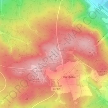
Name: Rotbühl topographic map, elevation, terrain.
Average elevation: 601 m
Minimum elevation: 452 m
Maximum elevation: 676 m
Other topographic maps
Click on a map to view its topography, its elevation and its terrain.
Mertenberg
Deutschland > Bayern > Landkreis Amberg-Sulzbach > Schnaittenbach
Mertenberg, Schnaittenbach, Landkreis Amberg-Sulzbach, Bayern, 92253, Deutschland
Average elevation: 540 m
Neuersdorf
Deutschland > Bayern > Landkreis Amberg-Sulzbach > Schnaittenbach > Neuersdorf
Neuersdorf, Schnaittenbach, Landkreis Amberg-Sulzbach, Bayern, Deutschland
Average elevation: 445 m