
Kjoestendil topographic map
Interactive map
Click on the map to display elevation.
About this map
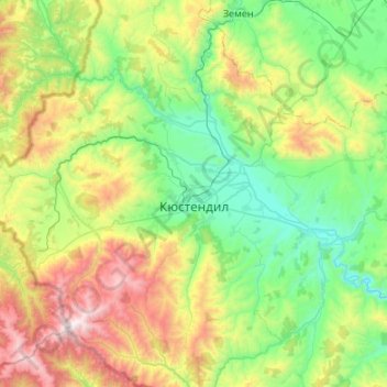
Name: Kjoestendil topographic map, elevation, terrain.
Location: Kjoestendil, Кюстендил, Bulgarije (42.10252 22.35980 42.48571 22.89789)
Average elevation: 937 m
Minimum elevation: 402 m
Maximum elevation: 2,246 m
Other topographic maps
Click on a map to view its topography, its elevation and its terrain.
Боровец
Bulgarije > Кюстендил > Кочериново > Боровец
Боровец, Кочериново, Кюстендил, 2640, Bulgarije
Average elevation: 412 m