
Derebağ topographic map
Interactive map
Click on the map to display elevation.
About this map
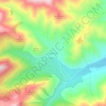
Name: Derebağ topographic map, elevation, terrain.
Location: Derebağ, Yahyalı, Région de l'Anatolie centrale, Turquie (38.05549 35.27802 38.09549 35.31802)
Average elevation: 1,516 m
Minimum elevation: 1,270 m
Maximum elevation: 1,859 m
Other topographic maps
Click on a map to view its topography, its elevation and its terrain.