
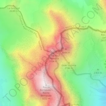
Cime de la Planette topographic map
Interactive map
Click on the map to display elevation.
About this map
Name: Cime de la Planette topographic map, elevation, terrain.
Location: Cime de la Planette, Bardonnèche, Turin, Piémont, Italie (45.10940 6.62995 45.10950 6.63005)
Average elevation: 2,590 m
Minimum elevation: 2,069 m
Maximum elevation: 3,215 m
Other topographic maps
Click on a map to view its topography, its elevation and its terrain.
Vallée Étroite
Italie > Piémont > Bardonnèche
Vallée Étroite, Cëriérë dla Cumbëtta, Grange Serres, Bardonnèche, Turin, Piémont, 10052, Italie
Average elevation: 1,653 m
Vallone di Almiane
Italie > Piémont > Bardonnèche
Vallone di Almiane, Decauville, Grangia Chaux, Bardonnèche, Turin, Piémont, Italie
Average elevation: 2,436 m
Valle di Rochemolles
Italie > Piémont > Bardonnèche
Valle di Rochemolles, gran via, Grange Mouchecuite, Bardonnèche, Turin, Piémont, 10052, Italie
Average elevation: 2,220 m