
Kerguelen topographic map
Interactive map
Click on the map to display elevation.
About this map
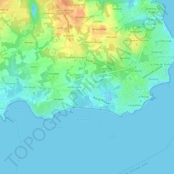
Name: Kerguelen topographic map, elevation, terrain.
Average elevation: 10 m
Minimum elevation: -1 m
Maximum elevation: 39 m
Other topographic maps
Click on a map to view its topography, its elevation and its terrain.
Les Quatre Chemins
France > Bretagne > Morbihan > Larmor-Plage
Les Quatre Chemins, Larmor-Plage, Lorient, Morbihan, Bretagne, France métropolitaine, 56260, France
Average elevation: 10 m
Le Bourrigo
France > Bretagne > Morbihan > Larmor-Plage > Le Bourrigo
Le Bourrigo, Larmor-Plage, Lorient, Morbihan, Bretagne, France métropolitaine, 56260, France
Average elevation: 7 m
Locqueltas
France > Bretagne > Morbihan > Larmor-Plage
Locqueltas, Larmor-Plage, Lorient, Morbihan, Bretagne, France métropolitaine, 56260, France
Average elevation: 6 m
Kerpape
France > Bretagne > Morbihan > Larmor-Plage
Kerpape, Larmor-Plage, Lorient, Morbihan, Bretagne, France métropolitaine, 56260, France
Average elevation: 10 m
Le Bourg
France > Bretagne > Morbihan > Larmor-Plage
Le Bourg, Larmor-Plage, Lorient, Morbihan, Bretagne, France métropolitaine, 56260, France
Average elevation: 6 m