
Make a donation
Gear up for your next adventure:
As an Amazon Associate, this site earns from qualifying purchases at no extra cost to you.
Cromwell Community topographic map
Click on the map to display elevation.
Make a donation
Gear up for your next adventure:
As an Amazon Associate, this site earns from qualifying purchases at no extra cost to you.
About this map
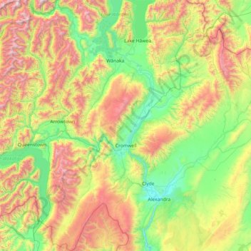
Name: Cromwell Community topographic map, elevation, terrain.
Average elevation: 876 m
Minimum elevation: 133 m
Maximum elevation: 2,593 m
Make a donation
Gear up for your next adventure:
As an Amazon Associate, this site earns from qualifying purchases at no extra cost to you.
Other topographic maps
Click on a map to view its topography, its elevation and its terrain.
Ranfurly
New Zealand > Otago > Central Otago District > Maniototo Community
Ranfurly is a town in the Central Otago District of Otago, New Zealand. Located 110 kilometres (68 miles) north of Dunedin, it lies in the dry rough plain of Maniototo at a moderately high altitude (around 430 metres or 1,410 feet above sea level) close to a small tributary of the Taieri River. It operates as…
Average elevation: 428 m
Bannockburn
New Zealand > Otago > Central Otago District > Cromwell Community
Average elevation: 279 m
Make a donation
Gear up for your next adventure:
As an Amazon Associate, this site earns from qualifying purchases at no extra cost to you.
Clyde Dam
New Zealand > Otago > Central Otago District > Vincent Community > Clyde
Average elevation: 318 m
Saint Bathans Range
New Zealand > Otago > Central Otago District > Cromwell Community
Average elevation: 1,222 m
Hawkdun Range
New Zealand > Otago > Central Otago District > Vincent Community
Average elevation: 1,112 m
Pātearoa / Rock And Pillar Range
New Zealand > Otago > Central Otago District > Maniototo Community
The vegetation of the high elevation habitats of the Rock and Pillar Range has been the subject of numerous studies by New Zealand botanist Alan Mark and colleagues. The Rock and Pillar Range has a similar alpine vegetation to other mountain ranges in Central Otago, such as the Old Man Range. In the Rock and…
Average elevation: 937 m
Make a donation
Gear up for your next adventure:
As an Amazon Associate, this site earns from qualifying purchases at no extra cost to you.
Naseby
New Zealand > Otago > Central Otago District > Maniototo Community
Naseby is a small town in the Maniototo region of Central Otago, New Zealand. The town catch phrase is "2000 feet above worry level" indicating its altitude. The town is 140 km (90 mi) from Dunedin. The centre of the town is a registered historic area, and there are many heritage buildings. Naseby has hot…
Average elevation: 619 m
Mount Kāmaka
New Zealand > Otago > Central Otago District > Cromwell Community
Average elevation: 905 m
Ettrick
New Zealand > Otago > Central Otago District > Teviot Valley Community
Average elevation: 105 m
Ranfurly
New Zealand > Otago > Central Otago District
Ranfurly is a town in the Central Otago District of Otago, New Zealand. Located 110 kilometres (68 miles) north of Dunedin, it lies in the dry rough plain of Maniototo at a moderately high altitude (around 430 metres or 1,410 feet above sea level) close to a small tributary of the Taieri River. It operates as…
Average elevation: 428 m
Make a donation
Gear up for your next adventure:
As an Amazon Associate, this site earns from qualifying purchases at no extra cost to you.
Bannockburn
New Zealand > Otago > Central Otago District > Cromwell Community
Average elevation: 279 m
Central Otago
New Zealand > Otago > Central Otago District > Vincent Community
Average elevation: 935 m
Cromwell
New Zealand > Otago > Central Otago District > Cromwell Community > Cromwell
Average elevation: 330 m
Make a donation
Gear up for your next adventure:
As an Amazon Associate, this site earns from qualifying purchases at no extra cost to you.