
Make a donation
Gear up for your next adventure:
As an Amazon Associate, this site earns from qualifying purchases at no extra cost to you.
Oxapampa topographic map
Click on the map to display elevation.
Make a donation
Gear up for your next adventure:
As an Amazon Associate, this site earns from qualifying purchases at no extra cost to you.
Oxapampa
Oxapampa pertenece a la región natural conocida como selva alta, pues se encuentra a una altitud aproximada de 1800 msnm. A 80 km del valle de Oxapampa y a unos 800 msnm, se encuentra el asentamiento de Pozuzo.
Make a donation
Gear up for your next adventure:
As an Amazon Associate, this site earns from qualifying purchases at no extra cost to you.
About this map
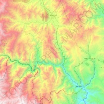
Name: Oxapampa topographic map, elevation, terrain.
Location: Oxapampa, Pasco, Perú (-10.90148 -75.48076 -10.51887 -75.28390)
Average elevation: 2,122 m
Minimum elevation: 701 m
Maximum elevation: 3,945 m
Make a donation
Gear up for your next adventure:
As an Amazon Associate, this site earns from qualifying purchases at no extra cost to you.
Other topographic maps
Click on a map to view its topography, its elevation and its terrain.
Make a donation
Gear up for your next adventure:
As an Amazon Associate, this site earns from qualifying purchases at no extra cost to you.