
Make a donation
Gear up for your next adventure:
As an Amazon Associate, this site earns from qualifying purchases at no extra cost to you.
Kiserian topographic map
Click on the map to display elevation.
Make a donation
Gear up for your next adventure:
As an Amazon Associate, this site earns from qualifying purchases at no extra cost to you.
About this map
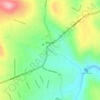
Name: Kiserian topographic map, elevation, terrain.
Location: Kiserian, Kajiado West, Kajiado County, Rift Valley, Kenya (-1.44164 36.67785 -1.42304 36.69419)
Average elevation: 1,847 m
Minimum elevation: 1,778 m
Maximum elevation: 1,939 m
Make a donation
Gear up for your next adventure:
As an Amazon Associate, this site earns from qualifying purchases at no extra cost to you.
Other topographic maps
Click on a map to view its topography, its elevation and its terrain.
Mount Suswa
Kenya > Kajiado County > Kajiado West > Ewuaso Oonkidong'i ward
Average elevation: 2,044 m
Make a donation
Gear up for your next adventure:
As an Amazon Associate, this site earns from qualifying purchases at no extra cost to you.
Make a donation
Gear up for your next adventure:
As an Amazon Associate, this site earns from qualifying purchases at no extra cost to you.