
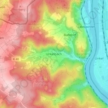
Unkelbach topographic map
Interactive map
Click on the map to display elevation.
About this map
Name: Unkelbach topographic map, elevation, terrain.
Average elevation: 154 m
Minimum elevation: 49 m
Maximum elevation: 252 m
Other topographic maps
Click on a map to view its topography, its elevation and its terrain.
Kripp
Deutschland > Rheinland-Pfalz > Landkreis Ahrweiler > Remagen
Kripp, Remagen, Landkreis Ahrweiler, Rheinland-Pfalz, Deutschland
Average elevation: 75 m
Rolandswerth
Deutschland > Rheinland-Pfalz > Landkreis Ahrweiler > Remagen
Rolandswerth, Remagen, Landkreis Ahrweiler, Rheinland-Pfalz, 53179, Deutschland
Average elevation: 106 m
Oberwinter
Deutschland > Rheinland-Pfalz > Landkreis Ahrweiler > Remagen > Oberwinter
Oberwinter, Remagen, Landkreis Ahrweiler, Rheinland-Pfalz, 53572, Deutschland
Average elevation: 120 m
Dungkopfsee
Deutschland > Rheinland-Pfalz > Landkreis Ahrweiler > Remagen > Unkelbach
Dungkopfsee, Unkelbach, Remagen, Landkreis Ahrweiler, Rheinland-Pfalz, 53424, Deutschland
Average elevation: 177 m
Bandorf
Deutschland > Rheinland-Pfalz > Landkreis Ahrweiler > Remagen > Bandorf
Bandorf, Remagen, Landkreis Ahrweiler, Rheinland-Pfalz, 53572, Deutschland
Average elevation: 131 m
Kripp
Deutschland > Rheinland-Pfalz > Landkreis Ahrweiler > Remagen > Kripp
Kripp, Remagen, Landkreis Ahrweiler, Rheinland-Pfalz, 53545, Deutschland
Average elevation: 88 m